
Event
Please join us for coffee, croissants, and conversation during the Spring Semester's Urban Studies Graduate Student Colloquium Series!The series provides a way for graduate students who are or have been a part of the Urban Studies Certificate program to come together to share their work. Most colloquia run from 9:30-11:00am unless otherwise noted.
Author: Professor Min Lee, Post-Doctoral Fellow and Visiting Instructor of Art History, Swarthmore college
Discussant: David Brownlee, Frances Shapiro-Weitzenhoffer Professor, Chair of the Graduate Group in the History of Art
Abstract:
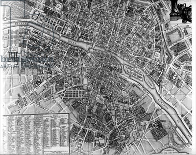
Immediately after the February revolution of 1848, Theodore Jacoubet as the head of the office of plans in Paris authored a study urgently calling for a new system of organization for the growing city. He located the problem concerning the displacement of the population from the central district of Les Halles in the piecemeal interventions executed by previous administrators. A total view of Paris was essential to keep its center coherent and stable.
Jacoubet executed a set of gridded maps that were the basis for the planning of Paris under the direction of the prefect Georges-Eugène Haussmann who served Napoleon III during the Second Empire of France. And while Haussmann’s applications represented a new idea of planning, the maps on which his engineers drew their projections were from surveys executed in the late eighteenth century.
By focusing on the practices of drawing and mapping, this presentation poses two critical questions concerning the transformation of Paris during the nineteenth century: firstly, from what base were the plans of Paris drawn; and, secondly, what was the logic of those drawn projections? The theoretical and historical significance of these issues is located in how instruments of urban planning mediate the production of spatial and built forms, and how the history of Paris’ transformation is part of a longer history of cartographic and urban representations to which the practice of urban planning is linked.
Photo: Plan of the City of Paris, early 19th century (engraving) (b&w photo), French School, (19th century) / Private Collection / Roger-Viollet, Paris / The Bridgeman Art Library